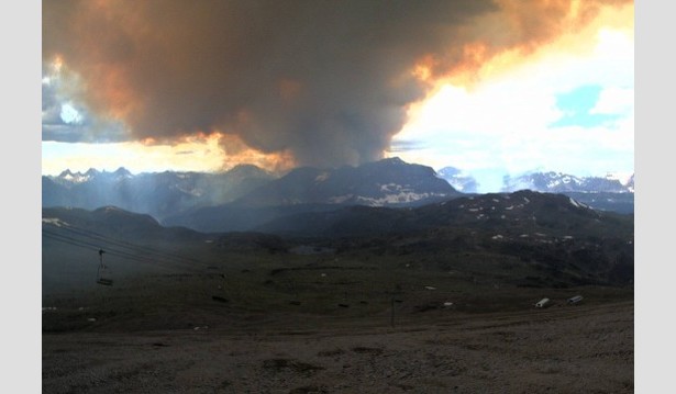
Sunshine’s Great Divide webcam captures the Verdant Creek wildfire boiling up behind The Monarch on Sunday afternoon, July 16.
Update July 31, 2017—Trails in the Sunshine Meadows and north along the Bow Valley Highline (Simpson Pass, Healy Pass, Egypt Lake, Whistling Pass) reopened Wednesday, July 26. But increased fire activity prompted Parks Canada to close the trails and Sunshine Village again on Monday, July 31st. For the latest on fire activity and closures, check Parks Canada’s Kootenay National Park wildfire status page.
A lightning-ignited wildfire in Kootenay Park’s Verdant Creek valley has forced Parks Canada to close a number of trails in Kootenay and Banff National Parks, including the popular Egypt Lakes area and the Bow Valley Highline backpacking route.
On July 18, the closures were expanded to cover all trails in the Sunshine Meadows area and in the northern half of Mount Assiniboine Provincial Park. Gondola/shuttle bus access to Sunshine Village is still operating.
The fire started following an electrical storm that passed over Kootenay Park Monday evening, July 10. When it sprang to life on the weekend, Parks Canada closed adjacent trails and evacuated campers along the busy Bow Valley Highline hiking region on the eastern slope of the Great Divide.
A front moved across the region from the northwest on Sunday afternoon, bringing strong, gusty winds that pushed the fire into Mount Assiniboine Provincial Park and up the Simpson River valley. Closures will not likely be lifted until the fire is brought under control.
Trails in the closed area include the following, each of which is detailed in the Canadian Rockies Trail Guide:
Banff National Park
Sunshine Meadows Loop
Quartz Hill-Citadel Pass
Simpson Pass-Healy Meadows
Healy Pass-Egypt Lake
Egypt Lake via Pharaoh Creek
Egypt Lakes Area Hikes
Bow Valley Highline Trail (km 0.0 to km 21.0)
Kootenay National Park
Honeymoon Pass-Verdant Creek
Simpson River-Ferro Pass
Mount Assiniboine Provincial Park
Mount Assiniboine via Citadel Pass (north of Og Lake Campground)
More Wildfire Information
Individuals with backcountry reservations should contact 403-762-1556 or visit a Parks Canada Visitor Centre. For fire updates and maps, check Parks Canada’s Kootenay National Park wildfire status page.
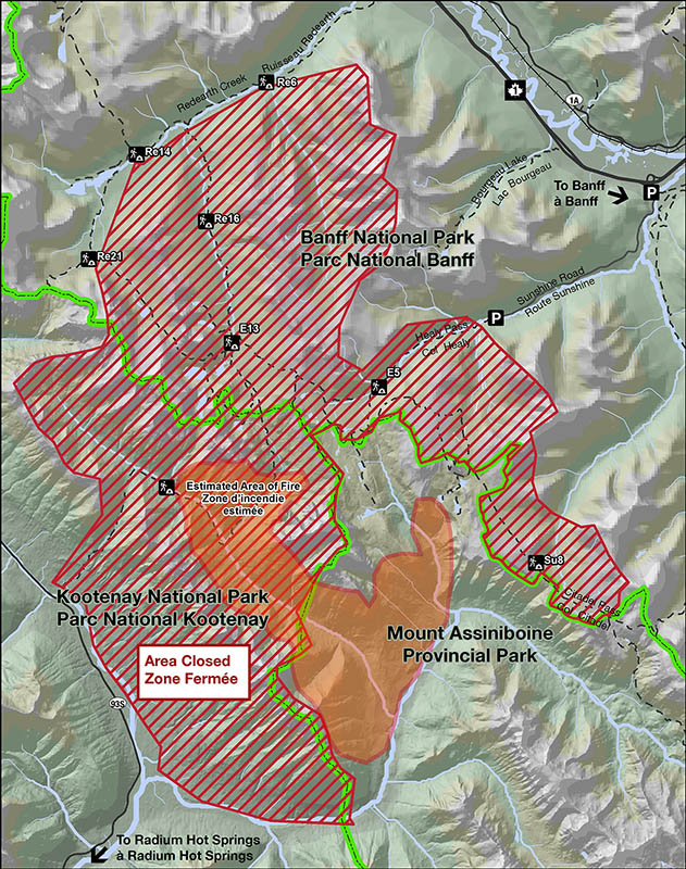
Parks Canada map showing closed areas as of July 17,2017
0 Comments