Cut off by a collapsed suspension bridge in 2016 and devastation from the 2017 Verdant Creek Wildfire, the Simpson River-Surprise Creek-Ferro Pass route into Mount Assiniboine Provincial Park has been restored thanks to a new bridge and trail clearing up the charred Surprise Creek valley.
The 32-km trail from Kootenay National Park into the heart of Mt Assiniboine Provincial Park has never been the most popular route into one of British Columbia’s oldest and most celebrated provincial parks.
Most people backpacking to Mount Assiniboine’s core at Lake Magog travel from Alberta, via either the Bryant Creek or Sunshine Village-Citadel Pass trails. Others fly by helicopter from Canmore or Mount Shark. Either way, access is shorter and faster.
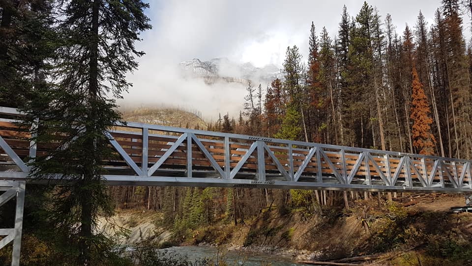
A new aluminum bridge spanning the Simpson River to the Surprise Creek trail renews access to one of Mount Assiniboine Park’s most remote valleys. Photo courtesy of Ethan Baltrus/Mountaineer Woodworks.
However, Simpson River-Surprise Creek-Ferro Pass is the only maintained trail originating in B.C. While the route is significantly longer than those from Alberta, it provides more of a wilderness experience and unique scenic rewards.
Most backpackers who hike the entire trail use it on their departure from Lake Magog (starting at Magog’s 2165m elevation and finishing up at 1250m in Kootenay Park).
But even more people hike the relatively flat 11.5-km trail from the Kootenay Park trailhead to the Surprise Creek campground and shelter. They overnight there and return the way they came.
Simpson River to Surprise Creek
The trail up the Simpson River to Surprise Creek has suffered a few indignities since we first measured it for the 2nd edition of the Canadian Rockies Trail Guide. It was lush and green in those days. But the Mount Shanks Fire in 2001 scorched most of the route and there has been little regrowth since then.
Expect open views and trail that is a bit sloppy in spots as you make your way east into Mount Assiniboine Provincial Park and to the confluence of the Simpson and Surprise Creek at km 10.9.
The old suspension bridge spanned the Simpson River to the Surprise Creek Campground and shelter cabin at this point. However, it collapsed in 2016 and BC Parks removed the wreckage soon after.
You’ll have to hike another 200 to 300 m further upstream to find a new aluminum footbridge over the Simpson (constructed in early autumn 2019). Then you’ll hike back downstream to the campground and shelter, adding an extra 500m to the trip.
Both the campground and cabin were spared from both the Mount Shanks and Verdant Creek (2017) fires— a little patch of forest green sandwiched between two charred landscapes.
Surprise Creek Cabin
The shelter cabin at Surprise Creek has an interesting history. Hunting has been allowed on the upper Simpson River since Assiniboine Park’s earliest days.
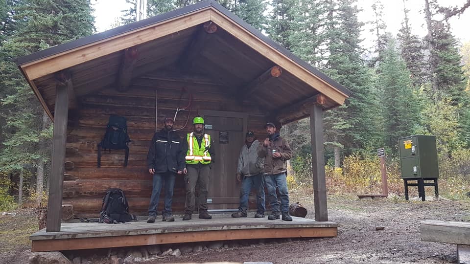
Ethan Baltrus (left) and fellow crew members from Invermere following restoration of the Surprise Creek Cabin in October 2019. Photo courtesy of Ethan Baltrus/ Mountaineer Woodworks.
Pioneer Columbia Valley outfitter Walter Nixon held the license to the upper Simpson guide block until his death in 1952. Albert Cooper, one of his guides, purchased the license from his widow and ran fall trophy game hunts (mostly sheep) in the area until 1996.
While Nixon and Cooper operated out of the Policemen’s Meadows cabins at the headwaters of the Simpson, Cooper built the Surprise Creek Cabin in the 1960s. An agreement with BC Parks allowed him to use the cabin in the fall for hunting so long as hikers could use it as a shelter during the summer.
The crew who flew in to construct the new Simpson River bridge in the fall of 2019 also refurbished the cabin, including a new roof, floors and door.
Surprise Creek Campground to Ferro Pass
According to our original measurements, the distance between Surprise Creek Campground and Ferro Pass is 12 kms. The first 2.5 kms above the cabin and campground are quite steep. You enter the scorched remains of the Verdant Creek fire shortly after you begin your climb above the campground and you hike through it all the way up the Surprise Creek valley to within 500m of Ferro Pass.
Though the trail was cleared and Rock Lake Campground facilities repaired in 2019, the usual hazards remain—danger trees (fire-damaged trunks, roots and branches), terrain instability, hidden ash pits.
Ferro Pass to Lake Magog
The trail to Lake Magog (campground and Assiniboine Lodge) remains basically unchanged and as described in the Canadian Rockies Trail Guide.
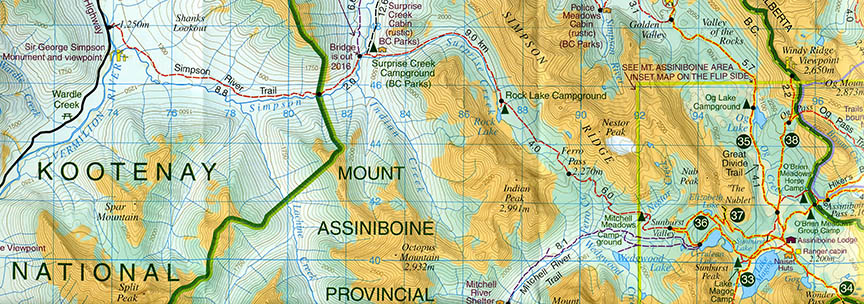
Detail from Gem Trek’s Banff & Mount Assiniboine map shows the Simpson River-Ferro Pass route from Kootenay National Park into the core of Mount Assiniboine at Lake Magog. A new version of the map (currently in production) will show trail rerouting to the new aluminum bridge 200m north of the old suspension bridge crossing.
there is so beautiful
tnx for news
I just came back from this route, both directions. I found the Surprise Creek cabin unlocked and without any COVID-19 notice, although I didn’t go inside. I also forded Simpson River instead of using the bridge (forgot that there was one), on the way up. I had the route to myself, except for one couple briefly.
I found the whole route pretty hard going, inbound. Maybe because it was so devastated by fire, that it was a bit dispiriting – and there was a lot of smoke from US wildfires at the time. But it was surprisingly easy to get up Ferro Pass from Mitchell Meadows on the way out.
I would use the other access routes (which I have used before) in preference to this one if visiting again.
Hi,
I was wondering if you could tell me anything about Mitchell’s Meadow Campground. Specifically finding it from Magog Lake. We will be coming in from the Mt. Shark trailhead. We are having a hard time finding any specific information about MM. Thanks!
Hi Sarah, Mitchell Meadows CG is located on Nestor Creek 3 kms west of Cerulean Lake. It has the distinction of being the closest campground to the core area of Mount Assiniboine where fees and reservations are not required (three first-come, first-served campsites). The campground is located on the well-trodden and signed trail to Ferro Pass, and there is an 170m elevation loss from Cerulean and Lake Magog.
Hi Brian and Sarah,
I too have been having extreme difficulty finding any information on the internet or through phone calls on how to access this campground. Have either of you stayed there? How come the CG are farther up the valley then the trail shows on any maps? It looks like there are a few streams including Nestor Creek, is there any issues accessing the campgrounds? Are there only 3 spots for tents and it is on a first come first serve basis?
Many thanks in advance, all information would be much appreciated!
-Hailey