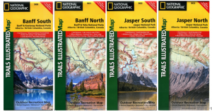
In 2012, National Geographic produced four maps covering Banff South, Banff North, Jasper South and Jasper North. These 1:100,000-scale, double-sided maps are printed on waterproof, tear-resistant material and with 30m-contour intervals and relief shading. In addition to Banff and Jasper, they cover Kootenay, Yoho, Mt Assiniboine and the core area of Mount Robson parks.
Thanks to careful input from Parks Canada and BC Provincial Parks, the placement of trails, backcountry campsites and other cultural features is excellent. And National Geo claims the maps will be “revised regularly.”
Cons: The maps are very large and unwieldy (65 x 95 cm), and the scale isn’t very useful for shorter hikes, where you might want to see more topographic detail. Still, excellent National Geographic quality and an affordable overview of the Mountain Parks.
You can order these maps directly from National Geographic Trails Illustrated, but the series is showing up in a few outlets around the Mountain Parks, like Friends of Jasper (at the visitor centre shop or online) and The Viewpoint in Banff and Lake Louise.


0 Comments