The trail to the Castleguard Meadows via Alexandra and Castleguard Rivers has never been easy. But since we first included it in the Canadian Rockies Trail Guide, there has been no maintenance and things have only gotten worse. A few intrepid backpackers make the journey each summer, either via the 35-km trail or cross-country over the Saskatchewan Glacier. Here is a current look at the entire route, trail and glacier, as travelled earlier this month by blog contributor Gavin Fitch.
Overlooking the Saskatchewan Glacier from the pass at the northern edge of Castleguard Meadows. Gavin Fitch photo.
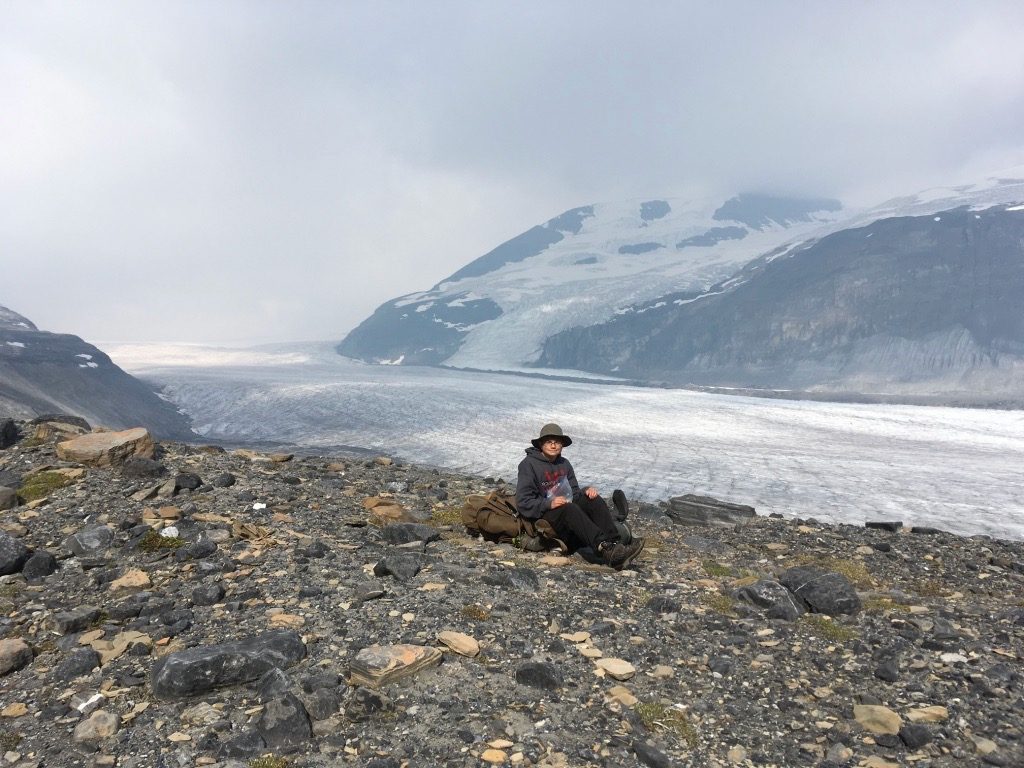
Last week, August 12-16, 2017, I hiked into Castleguard Meadows via the Alexandra and Castleguard Rivers with my son and an old friend. This trail has not been maintained by Parks Canada for many years and it shows. It is in poor shape and very demanding—a proper topo map and compass (and preferably a GPS unit) are a must. Fortunately, it is also very rewarding.
Alexandra River
After crossing the North Saskatchewan River on a good bridge, the fire road follows the river south before turning west up the Alexandra River valley. Not far from the trailhead you come to the first of many creek crossings. This first one has an old damaged bridge that is still useable. Enjoy it, because after that there are NO bridges the rest of the trail. About 3 km in, the trail is covered for a short distance by debris from an avalanche/slide. You have to bushwhack around this obstruction, below the trail. After that, things are fine until the trail comes to a crossing of the Alexandra River (11.7 km in the Trail Guide).
When we were there, the river was absolutely not fordable. We followed a discernible makeshift trail along the north bank of the river. However, it peters out after a short while (a couple hundred of metres). After bushwhacking for a while through overgrown forest, we gave up when we realized that the main channels of the river had moved to the south side of the valley. So we descended out of the forest, crossed a sluggish side channel and then walked along the river flats the rest of the way to Terrace Creek. It was actually really nice walking: the valley is flat as a pancake and very wide with beautiful unobstructed views up and down valley.
At the confluence of Terrace Creek and Alexandra River there is an old outfitters camp, complete with a dilapidated cabin and crumbling corrals. This is where we camped. The next morning we forded Terrace Creek, which was significantly lower than it had been in the afternoon—something to keep in mind when considering where you want to camp. On the other (west) side of Terrace Creek there is another old campsite, complete with a bench. We picked up the fire road just upstream (north) of the campsite. From Terrace Creek to the old Castleguard Warden Cabin, the fire road goes west in a more or less straight line, in and out of the forest and the river flats. On the flats it becomes very faint at times but the way is always obvious.
Castleguard Valley
The trail swings uphill away from the river just before reaching the old warden cabin. It carries on to the left of the cabin and then drops into a low and wet creek valley. Beyond the cabin, the trail is VERY overgrown with willows. We lost the trail in the low area beyond the cabin before picking it up again on the right bank. The first 4 km or so past the cabin is dark and gloomy—the Castleguard valley is narrow and the forest is thick and close. Fortunately, just past 4 km the trail gets within eyeshot of the Castleguard River. It is awesome—a classic mountain torrent racing through narrow canyons and thundering over small falls. There are several fantastic views of the river over the next 4 km or so.
At about 8.5 km from the cabin you come to a major tributary that must be forded. We arrived late in the afternoon and the water was high. On the left side of the trail there is an old fire ring and just downstream from that is another fire ring and a clear flat space big enough for a couple of small tents. We decided to camp there for the night. In the morning, as with Terrace Creek, the water level in the creek was much lower and the ford not too bad. From the ford, it is a short distance to where the trail comes back to the Castleguard River.
Based on the topo map, this is where the trail west to Watchman Lake and Thompson Pass branches to the left, across the river. I would not want to ford the Castleguard and we could see no discernible trail on the opposite bank. The trail to the Meadows, however, swings to the right along the near bank of the Castleguard. Soon there are a couple of nasty fords over tributaries—nasty not because they are wide or deep but because the creek valleys run down a fairly steep slope and are choked with deadfall.
Not far from where the trail turns right to follow the near bank of the Castleguard River, there a couple of nasty fords–nasty not because they are wide and deep but because the terrain is steep and the creek valleys are clogged with deadfall. On the far side of the second creek we lost the trail completely in the willows and deadfall. Spent a miserable hour or so bushwhacking but found it just before it begins the steep section below the meadows. This part was easy to follow. At the top of the climb the trail becomes faint as it enters the meadows but goes in a fairly straight line to a creek running through the east side of the meadows. The campsite is on the east bank of the creek. There is an old sign indicating the camp and a workable outhouse, which was nice.
In short, the trail to Castleguard Meadows is not for the faint of heart. It can only be described as being in poor condition and presumably getting worse every year. It’s a shame because, as advertised, the Meadows are glorious. We spent two nights there and I could have happily stayed longer.
Saskatchewan Glacier exit
Based on the misery we endured coming up the Castleguard River, we took the Saskatchewan Glacier route out. That was an amazing experience. The hike through the meadows to the glacier is wonderful. The only real difficulty is getting down the very large lateral moraine to access the glacier. It is steep and rocky and muddy. Once on the glacier, the walking was easy.
As you reach the toe of the glacier, it is obvious that there is much more space and flatter walking to the left (north) of the meltwater lake than the right (south). Yet the 1:50,000 topo map shows the trail on the south side of the valley, in particular on the south side of the Saskatchewan River. We trusted our eyes and chose the north side. There is no trail through the avalanche debris/river flats but the route is obvious–down the valley to where the forest begins.
When you finally reach the end of the flats, you pick up a trail on the north verge of the forest. This goes a short way before coming to a deep chasm where the river bends north. This chasm is “bridged” by a mishmash of very old fallen tree trunks–a rather exciting way to cross a deep (albeit very narrow, thank god) canyon.
Now, as per the map, you are on the south side of the river and the trail turns into an old fire road. From there the trail is good and it is a short way to the highway, at the “big bend”. Unfortunately, though the highway and parking lot are plainly in view you have to keep following the fire road farther south and then east. After a short while, there is a junction where the fire road bends south (right) and the trail stays east (left), following the river. It is not far from there to the trailhead, an old bridge of the North Saskatchewan.
What a hike!
It’s Gavin again. I feel I should say a bit more about walking on the glacier. While in one sense it was easy, you do need to careful. There are crevasses, but they are easy to see and most are very narrow. Some, however, are wide enough that you have to detour parallel to the crevasse until it gets narrow enough to cross. Lower down there are also meltwater channels that have to be jumped from time to time. All in all, not a problem so long as you are vigilant. And a very memorable experience that is preferable to bushwhacking through willows!
Thanks for the update on Castleguard. It was hard going back in ’82 when I hiked there with a couple of friends, and evidently it has gotten much, much worse. In the several updates of recent years, no one has mentioned “Otram’s Shower Bath”. It was by far the most memorable waterfall on the journey up from the valley floor to the Castleguard Meadows. It’s just below the entrance to the Castleguard Cave, which again no one seems to mention even though it’s a major geological feature of the Meadows plumbing system. Also, the description of the Meadows itself always seems glossed over. One of the most amazing features is the multitude of small sink holes with the sound of water gurgling and echoing underground. We camped by a rather innocuous looking hole around noon on a warm day, and by the late afternoon we had to move our tents to higher ground as the increased meltwater flow came up through the hole and created a small lake in the depression where our tents used to be. It disappeared overnight. Castleguard still remains in my memory as one of the major highlights of my hiking career, It was a true adventure.
Looking back now at all the trails that no longer exist throughout the Parks, I would have to consider that the period of my hikes in the late ‘70s and into the mid- ‘80s as the “Golden Age of Canadian Rockies Hiking”. I was very lucky to have spent so many rewarding years on so many trails that have faded or have been lost for good.
Brian, that little fire ring on the left, just before the ford is mine from a few years back. I wish I had read your blog in more detail before going back. I was there this weekend, and once again I was unable to make it to the meadows. I guess the key is fording those big creeks just under the waterfall. I don’t think I’m gong back a fourth time. Next time I’m going to the meadows via the glacier.
Martin Belanger
The reason nobody mentions the “Otram’s Shower Bath” is probably because a lot of people make the same mistake Marty and myself did and continued on the “trail” that goes up the two small waterfalls instead of crossing the Castleguard River where the non-existent trail was washed out, therefore skipping this section and ending up. There is now a cairn where to cross the river. It was still a fast-flowing river in September. I would be very careful earlier in the year. I made a little schematic with GPS coordinates for this tricky area. See the link below. Other than this section, it’s impossible to get lost from the trailhead up to the meadows. Finding the campground area in the meadows is tricky because the big tree with the sign is down and there are game trails everywhere. (PRIVY: 52.07704, -117.21232 +++ TENT AREA: 52.076804, -117.212755)
Thanks for all the information found on this page. Marty helped me planning my trip and I, in return, would like to share my findings for others to discover this exceptional area.
https://www.overthepeaks.com/trip-reports/trip-reports/alexandra-river-trail-castleguard-meadows-day4
Laurent T.-Blanchet
Hey guys,
Do you have a GPX for any of these routes? I would love to try it out!
Thanks.
Very interesting. Thanks for this and in particular the map you created. I would never have thought to cross the Castleguard.
We just returned from doing the Castleguard Loop: we walked up the Saskatchewan Glacier (on the north side of the lake, where it is easy to get onto the glacier). We climbed to the meadows through the gullies on the eastern side of the meadows. If there are several people in your group, make sure to each take your own gully, as you can and will set off rocks.
We camped at the campsite the first night. The outhouse is still in good shape. Tip: store your food in the outhouse, easier than creating a bear hang.
The trail down to the Castleguard river starts across the creek from the campsite. The location of the trail on most map sources is just an artist’s impression of where it could be – the real trail heads further west in a large loop. There is some deadfall, but otherwise it is easy to follow. It emerges right at the Big Springs/Outram’s Shower Bath Falls where there is a great little campsite.
If you want to explore Watchman and Cinema Lakes, cross the river here and head downstream about 100m or so until you see a faded white sign indicating the start of the trail. Again, an old trail, but easy to follow. There is a trail along the western shore of Watchman Lake up the headwall to cinema Lake.
The final day we crossed the Castleguard as outlined by Laurent (thanks for the tip!). From there it is easy to follow the trail to the warden cabin. Note that the river was still running high and fast, so the second crossing downstream from the campsite is not easy. Also, in September it is easy to see the crevasses on the glacier, but I would not go on it earlier when snow still obscures the crevasses.
We launched our packrafts just downstream from the cabin and floated out to Rampart Creek campground. Note that you should plan your take out at the campground as the main channel of the river hugs the far western shore of the valley until the campground. We learnt this the hard way, having to drag our gear across a marsh to get to our car at the Mt. Amery viewpoint. Doing the circuit this way was very enjoyable, and saved us from the hassle of the old fireroad!
Please note that Parks Canada has plans to burn down the Alexandra River Valley (prescribed fire: https://www.pc.gc.ca/en/nature/science/conservation/feu-fire/feuveg-fireveg/dirige-prescribed/projet-projects). Lucky for us, 2019 was a very wet year so it was postponed to 2020.
I invite everyone who wants to visit this area to do so before it’s too late. After the fire, the area will be impassable and the only way to visit the Castleguard Meadows will be from the Saskatchewan Glacier route.
As Rogier mentioned above, it is also possible to packraft the Alexandra River from the Warden’s Cabin back to the highway via a short section on the North Saskatchewan. It is a gorgeous trip Martin Belanger and myself did in June 2019.
A friend and I backpacked into the Meadows via the Saskatchewan Glacier and out via Alexandra River on August 16-20. Thanks, Laurent, for the gpx track. I was very helpful when the trail was faint or non-existent.
I can only add a couple of things. The Castleguard was running high and fast and fording twice to reach the cairn was outside of my risk tolerance. Erosion has left the cairn about 15 feet above the fastest part of the river on the edge of a steep river bank. Perhaps there are some conditions that permit a safe ford and passage in the river bottom. At other times, the best route is to bushwhack to just above Big Spring (source of Outram’s Shower Bath) and connect to a faint trail that passes above the smaller springs to reach the cairn. It was short and not hard and a lot safer and easier than fording the Castleguard.
We encountered two Parks conservation officers on horseback a couple of km east of Terrace Creek. They were enroute to the warden cabin and have cleared some of the worse deadfall between there and the Alexandra trailhead. They told us that they were the first Parks personnel to visit the cabin in four years.
As I write this two days out, I’m still feeling awe for the serenity and majesty of this special place. Our path took us through such varied terrain. Perhaps the best backpack I’ve had.
Thanks to everyone for all of these nice comments and videos that bring back my memories of making the trip up the Alexandra and Castleguard to the meadows and down the glacier way back in the 1980’s. Even then, with maintained trails, we had the entire area to ourselves. I would add that the side trips to Watchman and Cinema lakes are well worth the effort if still passable. Likewise, a scramble up along Terrace Creek reveals canyons reminiscent of Maligne or Marble Canyon. I always fantasized that the old outfitter’s ruins near the creek may have been Jimmy Simpson’s, who liked this valley and recommended it to Mary Schaffer. What a special area!
John, I just saw your comment about the outfitter’s cabin/shed along Terrace Creek.
I was there again in February, 2021 and visited the little cabin. I think it is really more of a shed, perhaps to cache supplies. There is more than one structure on the site, so perhaps one of the ruins belonged to Jimmy Simpson, but the existing shed, although dilapidated with a partially collapsed roof, seems too new. It is surely more recent than Jimmy Simpson’s time. Perhaps the little cabin ruin at Watchman Lake was his? It would be very interesting to research the origins of these structures. I wonder if they’ll survive the planned burn?
Scott and John
I think this is the source for information you are looking for
https://publications.gc.ca/collections/Collection/R61-16-11-2E.pdf