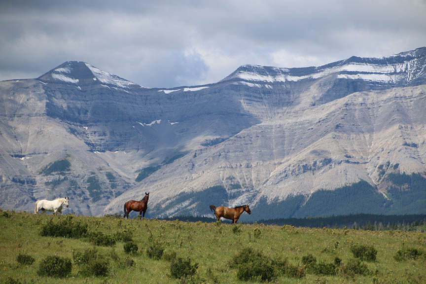
horses at Ya-Ha-Tinda Ranch
We’ve all had times when the best laid and ambitious plans have to be abandoned. That was the case this August when avid backpacker and faithful blog contributor Gavin Fitch set off from Ya Ha Tinda Ranch with three friends.
Despite the problems they encountered, Gavin’s description of the foreshortened trip provides an excellent review of current conditions on the Cascade Fire Trail.
2020 Cascade Fire Trail Trip – North Portion
by Gavin Fitch
Introduction
Sometimes things just don’t work out as planned. Sometimes it’s the result of bad planning. Sometimes it’s the result of unforeseen circumstances. And sometimes it’s a combination of both. It’s fair to say our trip this year fell into that last category:
Bad planning: the risk of not being able to ford the Red Deer River at the end of the Elkhorn Summit leg was clearly real and our fearless trip leader (yours truly) did not adequately account for it in planning the trip. My bad.
Unforeseen circumstances: Marco getting sick?! Come on. And Pat and me getting debilitating blisters? Not as unforeseeable but still unexpected.
But adapting to and overcoming adversity is part of going on an expedition. The question is how did you deal with it? More to the point, were you able to have a great trip anyway, notwithstanding the adversity? Having now spent several weeks thinking about and processing it, I believe the answer is a resounding Yes!
This is the first paragraph of the Canadian Rockies Trail Guide’s description of the Cascade Fire Trail:
The Cascade Fire Trail traverses the park’s remote Front Ranges, enclosing the Cascade and Red Deer Valleys. While there are no alpine passes on the trail, there is plenty of wild, rugged scenery, and you will experience a real sense of having escaped the madding crowds found elsewhere in the park. It is a region reserved for experienced, self-reliant wilderness travelers who are well schooled in how to travel and camp safely in prime grizzly bear habitat.
An apt description, one which perfectly captures the spirit of the long walk south from the Red Deer River bridge over Snow Creek Summit and down to the Panther River valley: spectacular scenery and no people. To me, the long second day from the Red Deer to the Panther ranks among the best and most memorable days of backpacking, notwithstanding the toll it took on us all (well, most of us).
In my mind, the trip breaks down into three distinct parts: (1) Getting to the Panther valley; (2) our sojourn in the Panther; and (3) walking back out.
Getting to the Panther valley
Day 1:
On the trail 11:30 am, Saturday, August 8. You have to laugh that our only real route-finding mistake occurred within metres of the parking lot, when we followed the road to Ya Ha Tinda’s ranch buildings rather than the old fire road. But it was a minor mistake and gave us those iconic views of the horses silhouetted against the Front Ranges of the Rockies. And we were so lucky with the weather on Day 1. All those squalls that kept blowing by to the south of us, so that we only got a small amount of rain on a very unsettled day.
We were finally able to leave the road to the ranch when we cleared the last of the fences, at which we point we started backtracking on the other side of the fenced pasture. Met our first two hikers who helpfully pointed us to a junction a short way ahead, which quickly brought us to the ford of Scalp Creek. Having missed the actual fire road, we rambled through a lightly forested area, stopping for lunch in an old burn. Our only real moisture blew in as we finished eating and for the first and I think only time in the entire trip we stopped to put on rain gear. But the squall passed quickly and before long we stopped again and took off our GoreTex.
Not long after that, we joined the fire road and our views opened up westward to Warden Rock and Wapiti Mountain, with the Red Deer River out of sight below us in the wide valley separating these two sentinel peaks. Whether because of its name or its imposing shape and aspect, but walking towards Warden Rock made me feel like we were approaching a clearly defined and official entry into the national park.
Reaching the park boundary (13.7 km) was the first milestone, aided by the unexpected pleasure of gaining the escort of two friendly dogs from the Outpost at Warden Rock: two thirds of Day 1 down, still dry and feeling (relatively) strong. The boundary is now fenced for the bison and there is a large welcome to Banff sign—some things have changed since 1992. Had a proper break, longer than lunch I think, as we were not being menaced by the weather and knew we had only 6 or so kms left.
Arrived at Tyrrell Creek shortly after 6 pm and set up camp in a group of small patches of sand among the stony flood channel of the creek. The traditional first night steak dinner was particularly good this year, I thought, assisted by our first bottle of red wine. And we got the dishes cleaned and our teeth brushed before the rain started falling. All in all, but for discovering that we could not ford the river and therefore could not do Elkhorn Summit, I’d say the first day was a success.
Day 2:
What a surprise it was waking up the next morning and finding ice on our fly sheets. The sky had cleared overnight and it got cold. But it was a beautiful day and as soon as the sun came up it was warm and we were able to mostly dry our flies and tarps during breakfast. Started walking at 9:40 am. The trail started with a gentle uphill away from the river, then turned south and dropped to the bridge across the Red Deer. Passed through a wide meadow and saw our only wildlife of the trip, two white-tailed deer bounding away from us into the trees on the far side of the meadow. Shortly before the bridge we met a group of 3 hikers who were on their way out from the Tyrrell Creek-Shale Pass-Divide Pass/Creek loop. Took our first break on the south side of the bridge. Beautiful spot above a canyon running in a strangely straight line from a bend upriver of the bridge.
After starting again, we came to a junction and went right. Soon we came to the edge of a large meadow and found ourselves looking up the Red Deer valley, towards what we later learned is the Scotch Camp warden cabin. Backtracked to the fire road and began a moderate climb around the northwest flank of Mount White. Now the trail was taking us due south, on the east side of a broad valley, and we started a long, gradual climb to Snow Creek Summit. Above us were the bare, lush green slopes of a succession of peaks of the Bare Range. Behind us were views across the Red Deer valley to Divide Pass and those damn elusive bison.
As the morning stretched into the afternoon, the sun was hot but there was a surprisingly cool wind, which was lucky because the trail was dry: part way up the west flank of Mt. White and the Bare Range, Snow Creek quite a ways below us in the valley bottom. You could tell this was an old road, as it was straight and level and wide in places in a way that mountain trails are not. Plus there were old trashed culverts here and there, where the road had washed out.
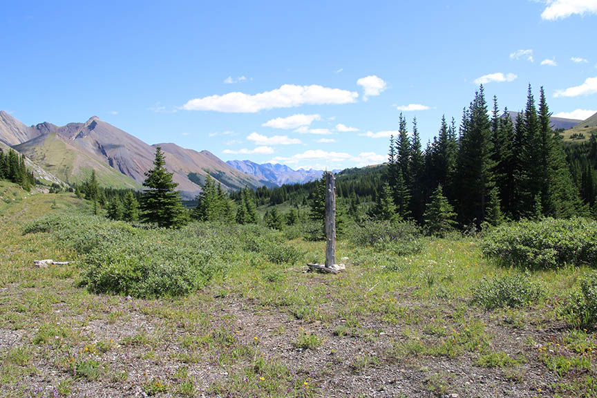
Snow Creek Summit looking south. Gavin Fitch photo.
On and on the trail slowly climbed toward the summit. It was maddening on the one hand, but on the other as we went the scenery got better and better, with long, broad views west and south to the Vermilion Range and a succession of limestone cirques. After stopping for lunch, we finally reached the summit, marked by an old gnarly sign post without a sign, which was presumably long gone. Beyond the summit, open meadows stretched south for miles and beyond that the aptly named Bare Range marched into the distance. Spectacular.
It had been about 13.5 km to the summit and we had another 10 to go. As we gradually descended through the meadow on the south side of the summit, we all began to feel the distance. Sore feet became blistered feet and the sun continued to beat down on us relentlessly as it moved into the west. At about 20 km we had our last break at a (barely discernible) junction with a trail to Harrison Lake. About 3.5 km to go and we were all beat. The trail was now traversing on the lower flank of a mountain with long green slopes above us and beyond the mountain was the forested valley of the Panther River.
Finally, we came to a bluff and there below us, through a burn, we could see the river, the Windy Warden Cabin and the bison paddock—the whole shebang. Not only that, we saw what looked like a bridge! So we descended the last hill to the river and, instead of fording, picked our way among the river rock and willows on the north bank of the river to the bridge. It was perfectly serviceable: two logs with a flattened surface with cross-hatching for grip.
Now we were on the south side of the river and after a short search found a perfect campsite among low trees and willows. Like the Tyrrell Creek campsite, we were on patches of sand among the river rocks, but larger and more sheltered. Next to the bison paddock, just downstream of the warden cabin. We’d made it. 24 km and seriously beat up. It was already evening and we didn’t eat dinner till after 8:30 pm or so. It was a gorgeous night and we had just enough light to wash up and get ready for bed. At this point, we knew anything closely resembling the original itinerary was not happening, which was disappointing, but were also relishing the prospect of a rest day.
The Panther Valley
Day 3:
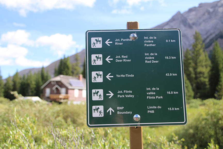
Windy Cabin, and a trail sign
Another beautiful starry night was followed by a late morning. After breakfast, everyone did their own thing. I limped to the warden cabin and (gasp) discovered a trail sign:
Then I backtracked past our cooking area and followed the cart track past the bison paddock to see if I could find the trail down the south side of the Panther. Sure enough, the cart track narrowed to a single track and disappeared into the willows of the meadow east of the paddock.
More importantly, Ellie discovered that the outhouse at the warden cabin was open. Hooray! Later, Ellie, Lief and I walked back to the warden cabin, found the far from obvious junction of the fire road with the trail to North Fork Pass, and followed it up a short forested slope to broad meadows above Panther Falls. As sore as my feet felt, my hiker’s heart badly wanted to keep going west to the pass. But we left the trail and bushwhacked to the falls, which of course were spectacular.
The afternoon was hot and languid. Our camp, being sheltered, was scorching hot and alive with horse flies, whereas the riverside was relatively cool and breezy. The elders all had splash baths to one degree or another in the river, which felt divine under the hot sun. Books were read; naps were had. Being the restless soul I am, I wandered across the bridge and up the bank on the other side to see if there was a real trail. There is not. I forded the river on my way back for the sake of my feet and prudently returned to reading/napping. Happy hour and dinner were leisurely and liberal with the whisky and red wine. After dinner, we watched the setting sun illuminate ever higher and smaller parts of the small peak across the river and Panther Mountain on our side before finally dropping below the Vermilion Range to the west. All in all, a lovely day.
Day 4:
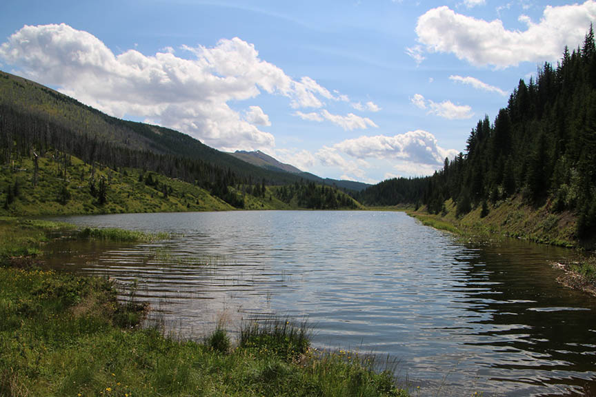
Beaver-flooded Wigmore Lake. Gavin Fitch photo.
The plan for the next day was to do a day hike. In order of difficulty, the options were: (1) N Fork Pass; (2) Panther River and Elkhorn Summit; (3) Wigmore Summit. Pat also suggested climbing the small peak across the river. As it turned out, Marco woke after a terrible night feeling sick as a dog. After manfully cooking breakfast for us (since my Peak 2 had crapped out on me), he crawled back into his tent. Given the state of my and Pat’s feet, we opted for the easiest hike, to Wigmore Summit. 12 km return.
We got going around 10:30 am. Our route was south on the fire road. Started a gradual climb through the trees. After three relatively easy fords of Wigmore Creek, the trees thinned and we entered open meadows of willow. Soon we had views southwest to a single classic limestone peak of the Vermilion Range. As we carried on, the view continued to open up and our one peak became two and two became three. We stopped for lunch at what seemed to be the summit, with views straight west to the three peaks. Pat was convinced that peaks that impressive (close to 3000 m) must be named so we consulted our maps. Nope, just unnamed peaks of the Vermilion Range. We figured out, though, that North Fork Pass was literally on the other side of those peaks. Once again, I wanted to get to that pass from the Panther valley.
After lunch, we carried on a short way south to Wigmore Lake. There was a series of beaver dams on Wigmore Creek below us, not something you see often in the Rockies. One result of this was that the level of the lake has risen, with the result that the fire road is now under water. At the north end of the lake, lying on the ground, was an old sign which read: “Wigmore Lake Alt. 6500”. From the lake it was another 33 km south to Lake Minnewanka and the beginning of the Cascade Fire Road. But that was as far as we went. The hike back to the Panther was uneventful, except for the fact that the condition of my and Pat’s heels continued to deteriorate.
Arrived back in camp at around 2:45 pm. Marco was still in his tent. Another lazy afternoon and evening. Marco emerged towards dinner and Pat fed him some of his homemade dehydrated tomato soup, following which Marco went straight back to bed.
Day 5:
We had decided to spend 3 days camped in the Panther, followed by 3 days back to Ya Ha Tinda. The next day, Day 5, should have been another day hike. But Marco was still recovering and Pat and I were suffering so we had another rest day. For me, this was the only disappointing day of the trip, as I think we were all getting bored with sitting around camp, as lovely as it was. But hey, if you have to get stuck somewhere, it was a pretty good place to get stuck.
Ellie and Lief crossed the river and found the route Lief had followed last summer to get the view of Panther Falls from the north side of the river. I have few memories of this day, other than that I obsessively tended to my foot, including limping around barefoot using my hiking pole as a crutch and not surprisingly stubbing my toe on a rock. Also, that it was clear and sunny but surprisingly cool until the afternoon.
Return to Ya Ha Tinda
Day 6:
Day 6 would be approximately 20 km, so we got up earlier, at around 7. The sky did not look promising; darkish clouds were looming in the west and it seemed likely they were headed our way with rain. So it was a pretty brisk teardown of camp and we were on the move by 9:30. Pat and I had carefully dressed our heels but were feeling trepidatious. After spending 3 days in the Panther valley it was sad pausing for one last look before the trail turned north at the top of the bank on the other side of the valley. But we were also itching to get moving again. Given the state of our feet we made good time and the walk was basically fine. Made it to Snow Creek Summit (10 km) with only a few stops.
Stopped for lunch at the small creek crossing we’d stopped at on our way in. After lunch we found without any problem the junction with the trail we were pretty sure would take us to Scotch Camp, our planned campsite for the night. It was lovely leaving the hardpacked fire road for a soft forest trail. We descended through a north slope forest with sphagnum moss carpeting the forest floor beside the trail until we finally reached the valley bottom. As we entered the meadows we saw a long expanse of fence and knew we were close to Scotch Camp.
The only problem being when we got there we found a warden cabin that (gasp) was actually open and a Parks Canada employee standing out front. Her name was Julie Timmerman and she was lovely—seemed genuinely delighted to see a group of hikers in this remote part of the park. We had a nice yak: told us she is a conservation officer, not a warden (though she used to be) and that wardens no longer go to the warden cabins! Instead, they carry guns and give tickets to campers in the frontcountry. Crazy. We commiserated about the sorry state of the trails in the Front Ranges and she gave us directions to what she assured us would be a lovely campsite, another 40 minutes or so farther. Of course I’d been hoping we were done for the day, but it wasn’t even 3 pm yet and my feet had settled into an acceptable state of agony.
Our way led through a gate in the fence and across the meadow/pasture, through the gate on the opposite side, and to the east edge of the meadow. As we guessed, this was the very place we’d got to on Day 2 when we went right instead of left at the junction on the south side of the Red Deer River bridge. On the other side of the bridge we left the fire road and followed a trail along the river. Before long, it led us to what we imagined was the spot Julie had told us about: down the riverbank to a small flat, open area next to a small pool off the main current of the river. We had camp set up before 4 pm and washed up in the river under a warm sun. The morning’s threatening weather had never materialized and the day had turned mostly sunny. Found a very old fire ring and the kids got a fire going, which was very nice. Quiet evening. Now we had only 24 km left, and two days to do it, so everyone was feeling pretty mellow I think.
Day 7:
Woke to a warm morning. No condensation on the tents and no dew on the grass. With approximately 12 km planned for the day, there was no need to get an overly early start. The trail we’d taken to camp was a good one so we decided to keep following it east instead of backtracking to the bridge to pick up the fire road. Good choice. It stayed generally close to the river and eventually led us into a meadow. The trail gradually angled away from the river through the meadow and led us to the fire road. Looking back, we realized that this was the meadow we’d seen the two white-tails bounding through on Day 2.
Now, even though our feet were sore, the end seemed clearly within reach. We followed the fire road back to the park boundary, where we stopped for lunch. Lief and Ellie figured we should camp there, down by the river, but their reconnaissance mission didn’t yield particularly enthusiastic site reviews, so we carried on. We passed the Outpost at Warden Rock and sadly were not joined by the dogs. Not far beyond that, we found a horse trail leading from the fire road along a dry drainage, toward the river. It entered trees and started paralleling the river. There were few obvious campsites but we found a small clear area along the trail large enough to fit the tents and hammocks, so we stopped for the day. Although we were clustered on either side of the trail, which was littered with liberal amounts of horseshit, it was a cozy spot.
Day 8:
The final morning. As always, we were motivated to get moving, even though we had only 12 km to cover. We were packed up and ready to go by 9:20. The night before we’d figured out that our trail petered out not far beyond where we were camped, so we backtracked. It took us 10 minutes to get back to the fire road. Now we had 12 km left and it was heads down and balls to the wall. This part of the hike, unlike most of the rest of it, really reminded me of walking through Ya Ha Tinda with John Tuckwell 28 years ago: hot, dry, sore feet, grasshoppers springing out of our way and absolutely amazing views back to Warden Rock.
We stuck to the fire road and missed the forested part of our route on Day 1. By about noon we reached Scalp Creek and knew we were near the end. Marco was far ahead, likely already at the parking lot. The rest of us briefly stopped at the creek to talk with a horse party, who told us the SHORTEST way to get to the trailhead. 15 minutes later we were done. It was sunny, hot and drop-dead gorgeous. Lucy arrived early, and with cold cider! A blissful way to end eight days in the Front Ranges.
Hello! Thanks for your blog. Went hiking around the Yaha Tinda Ranch last year and sad I waited so long. Now four of us are planning a long awaited multi-day hike through the mountains and settled on taking the Cascade Fire Road from Banff out to the Ranch. But surprised at how little info there seems to be on it especially since at face valley it seems like it would be one of the more beginner friendly trails through the park. Between this blog and your later blog on the Dormer pass trail via the southern stretch of the old road, I feel like I have a good understanding of what to expect, not to mention getting very excited for it. Thanks again!
The latest edition (2022) of the Canadian Rockies Trail Guide offers a detailed description of the trail (pages 166-168). But don’t try it before June (heavy snow this year). If you follow this description and discover any glitches, please let us know.