UPDATE: The section of South Boundary Trail referenced below in this post has been decommissioned and is now impassible. The South Boundary Trail now officially starts along the Cardinal River Road. The new route is described pages 236 to 240 in the Canadian Rockies Trail Guide, 10th edition.
Ever since the 2003 Syncline Ridge Fire scorched the section of Jasper’s South Boundary Trail between Jacques Lake and the Rocky River (also known as Breccia Creek section), travel has been iffy at best. Parks Canada didn’t have the resources to rehabilitate the trail, so nature was left to take its course.
Last week, Rogier Gruys, a Jasper Park Visitor Experience Specialist, decided to spend a long weekend investigating the trail’s condition. “It may be better than expected,” wrote Rogier as he prepared for his backcountry probe beyond Jacques Lake.
Rogier had a memorable trip, and his report back this week was not encouraging for anyone planning to hike the full South Boundary Trail.
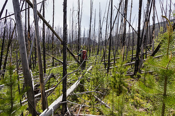
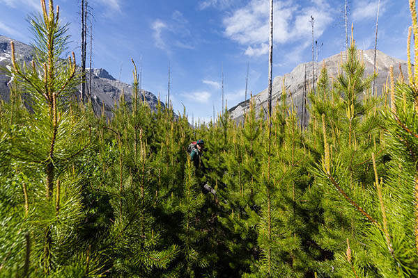
“The section of the South Boundary Trail between Jacques Lake and the site of the former suspension bridge across the Rocky River is a lot worse than we thought. It is extremely difficult to get through, and it will only get worse in the coming years. There are thousands of trees down, and thousands more that will fall down in the coming years. And there are equally many young pine trees, willow, alders and buffalo berries crowding the trail as well…. And since the bridge is out, it can only be completed in the fall when the Rocky River is low.”
Rogier recommends that “only extremely experienced and determined hikers should attempt this section of the trail.” And we recommend that backpackers bound for the South Boundary country skip this section and use Rocky Pass instead.
Where is the trail?
Can you find the trail? See photos below. The South Boundary Trail has suffered greatly in the wake of the 2003 Syncline Ridge Fire. Deadfall and regrowth makes it almost impossible to follow the track between Jacques Lake and Rocky River. Rogier Gruys photos.


Hi Everyone! I hiked the SBT a few days ago(August, 12th). I would like to give some updates: 1)the cardinal river fording is tricky, once you come down to the valley along a couple of switchbacks you need to continue upstream for at least 200/300m before you can ford( its a triple fording of cardinal river and the creek coming from the valley leading to Rocky Pass). 2) fording Southesk River: the hiker trail doesn’t exist anymore! It’s completely covered by fallen trees and logs once you pass the first seismic line and you climb up the ridge.
There are signs of a landslide close to a yellow diamond sign that indicates something happened up there. I strongly suggest to go via the horse trail, it’s a challenging fording but at least the trail is marked. The suspension bridge is still there but there’s no way to get there via the ridge on the north side.
3) most of the river fording lack of any sign whatsoever, so you need a real detailed map to know where to cross. I hope that was useful. Dani
^^^ The above e comment is not accurate. We JUST finished the SBT on July 31, 2019 and crossed the bridge. You CAN access the Southesk Suspension Bridge. Fording is not always possible due to water levels that are currently high. You CAN take the hiker trail.
Video to follow on our Youtube Channel. (howesthehike)
2020 update. The bridge is still there and looking good. I could update you on what I found, but the best news I can give is after hopping over trees for days is that I ran into Greg Horne the warden and his partner at Brazeau cabin just starting a 2 week trail clearing trip up the South Boundary Trail. I informed him of some difficulties I had and the trail should be much easier the rest of this season at least. I youtube but am so far behind now on editing (doing more backpacks takes precedence) that it’ll be around Christmas before I put out videos.