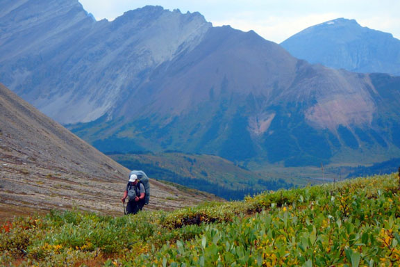
Climbing to Cairn Pass from the Medicine Tent Valley on Jasper’s South Boundary Trail. Jim Shipley photo.
We originally hiked and measured Jasper Park’s South Boundary Trail many years ago, but a lot has changed since then. Wildfires, floods, rampaging grizzly bears (well, we did have a rampaging grizzly bear). The only way we can keep the Canadian Rockies Trail Guide up-to-date for long, remote backpacks, like the South Boundary, is through updates from our readers.
Jim Shipley is one of those contributors. Every summer, Jim and his buddies complete a long backpack in the Mountain Parks. This year they chose Jasper’s remote South Boundary Trail. I advised Jim that the original northern section of the trail beyond Jacques Lake was no longer feasible, despite our trail guide description that still provides a trail outline from Jacques Lake to the Rocky River.
Jim and his buddies, Dan, Ryan and Darcy, hired Mr Taxi in Jasper to haul them in a crew-cab pickup and mini van to the Rocky Pass trailhead below Cardinal River Divide, just beyond Jasper Park’s east boundary. This is the preferred access to the north end of the South Boundary after a decade of post-wildfire regrowth has devoured the Breccia Creek route beyond Jacques Lake. After crossing Rocky Pass, the party reached the Medicine Tent River and headed south for the trail’s highlight, Cairn Pass (2255m).
You can trace the party’s progress to the Nigel Pass trailhead in Banff National Park by reading our South Boundary Trail description in the Canadian Rockies Trail Guide. But Jim provides some useful insights and a few new cautions along the way:
* The South Boundary Trail was closed during the first half of the summer due to a rambunctious grizzly bear(s) that was tearing into patrol cabins and tack sheds along the route. By the time Jim’s party started its trip in August, the closure had been lifted in place of a bear warning. On their second day, climbing from Medicine Tent Campground to Cairn Pass, they noticed a motion-sensitive “wilderness camera” focussed on a nearby bear-rub tree. The tree was wrapped with barbed wire to collect hair samples that might be used for DNA identification of passing bears, and maybe the marauding grizzly.
* As they hiked south from Cairn River Patrol Cabin to Cairn River Camp, they encountered several sections of trail washed out by the 2013 floods, particularly at the Cairn River ford. These washouts made travel and route-finding difficult at times, but they got through by following yellow diamond markers tacked to trees by Parks Canada.
* Not far beyond Cairn River Camp, they entered the 2006 burn, a stretch that can be hazardous due to falling snags, particularly during windy days. And like most burned wilderness trails, the route is often difficult to follow thanks to vigorous regrowth that is consuming the track.
* Beyond the Southesk River suspension bridge, they found signage to Southesk Campground confusing (and, apparently, our trail description as well). They never did discover the site.
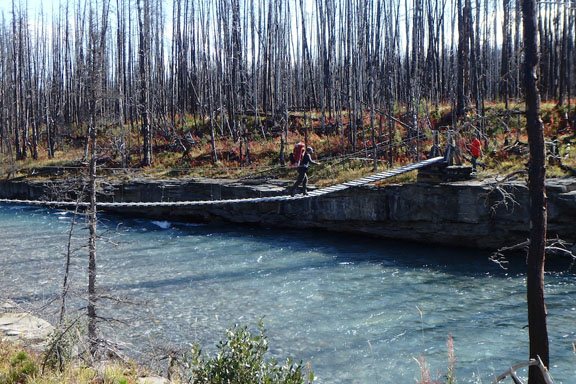
Southesk River suspension bridge in August, 2015. Jim Shipley photo.
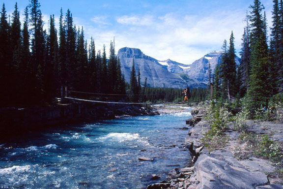
Southesk River bridge when we hiked it many years before the 2006 burn. Brian Patton photo.
Jim describes the Isaac Creek Patrol Cabin as “Bear Central”, and his party encountered a large stainless steel bear trap in the front yard and a high-resolution microphone for capturing wildlife sounds. (When we passed this way many years ago, the Isaac Creek cabin’s roof had just been removed by a ravenous grizzly.)
Also noted, hikers no longer cross to the east side of the Brazeau River between Brazeau River Campground and Jonas Pass Junction. Since the hiker bridges are no longer maintained, and fording the Brazeau is a hazardous enterprise, the trail along the east side of the river and the Wolverine South Campground is now reserved for horse parties. Hikers follow a secondary trail on the west side of the river throughout this section (the track is faint in some sections, but watch for square blazes on trees to stay on route).
Other than these comments, the South Boundary Trail remains pretty much as we describe it in the Canadian Rockies Trail Guide. But conditions are always changing in the backcountry, particularly on long, remote routes like the SBT. Always make sure all your questions are answered at the Jasper Visitor Centre trail desk before you set off on any wilderness adventure.
Read Jim Shipley’s detailed log, with photos, for the 9-day trip from Cardinal River Divide to Nigel Creek: South Boundary Trail trip report
Hi Brian. My son, an old friend and I just did the “Heart of the South Boundary” over Rocky Pass to Cairn Pass (July 22-25, 2016). A couple of comments.
First, we were not able to find the junction of the Rocky Pass trail from the seismic road that starts the hike. After wandering up and down the road a couple of times we finally just bushwhacked through very tall willows in a meadow and came upon the trail just shy of the outfitter’s camp and the first ford of the Cairn River. On our way out, we met a group of 10 hikers going in who also couldn’t find the junction. They spent so much time looking for it they had to spend their first night at the outfitter’s camp instead of at Medicine Tent. The reason we missed it (we think) is that the guide books suggest it is at or near where the seismic road meets the large meadow to the left. But it is not. It is before you can see the meadow from the road, while the road is still in forest. Coming out, we measured the distance from the trailhead to the junction at 1.7 km. You have to pay pretty close attention to find it, I would suggest. There are two small boulders flanking the trail just beyond the junction with the road.
Second, the dreaded willows are overgrowing certain sections of the trail, both the Rocky Pass section and the Medicine Tent – Cairn Pass section. We were all wearing shorts and our legs got pretty scratched up. Long hiking pants on this part of the SB is a good idea.
Otherwise, we had a wonderful time. We were impressed with the expanse of the alpine in both Rocky Pass and Cairn Pass in particular. I have no doubt that if it were more accessible, Cairn Pass would be one of the premier alpine destinations in all the Rocky Mountain parks. Spectacular. We also enjoyed the old-style campsites, particularly Cairn Pass with its hitching posts for horses, antlers nailed to posts, etc. The trail has both history and great scenery. Finally, there is that sense of total isolation. Until we met the party going in on our last day going out, we didn’t see a soul–other than a grizzly bear heading north on the trail as we were heading south towards Medicine Tent Lakes. That was exciting. Fortunately, he didn’t seem remotely interested in us and we carried on our way to the pass.
Thanks to you and Bart for publishing the Trail Guide. Our family has been using it since the early 1970s.
Just got back from doing Cairn Pass via Rocky Pass. Wet and cold, with snow one night. No trouble finding trail that runs parallel to seismic line and then crosses meadow thru willows before going down steep bank to Cardinal River. There are THREE crossings of the Cardinal, which was high due to rain. Expect to get wet and watch for flagging. Route up to Rocky Pass follows a stream much of the way and was very muddy and rocky; not fun. Rocky Pass was beautiful, with east views to the low ridges of the initial ranges and foothills and west to higher, more wild terrain. Note that the trail going down the west side of the pass DOES NOT follow the canyon but proceeds up to the left of the canyon before plunging into the forest past beautiful punch bowl falls. Once on the South Boundary Trail navigating is pretty straight forward, with exception of first washed out creek north of the Rocky P. and S. Boundary trails intersection. Keep close to river and follow flagging. We camped at La Grace Campground (better than Med Tent, but access to water a hassle) and day hiked to Cairn Pass (18 km return). Great hike, nice grades and we got to the top of Cairn Pass faster than anticipated. Extensive meadows did remind me of Maligne Pass. Med Tent Lakes very scenic. Thanks Brian (and Bart) for creating your trail guide. It is my hiking bible. I’ve hiked 103 of the 182 hikes mentioned in the 1972 edition!
Should make clear that trail parallel to seismic line is to the left (south) of the line and there are numerous access points to it from the line starting about a km or two from the start of the seismic line. For most of the way this parallel trail is no more than 5 to 10 m from the line. My belief is that this parallel trail exists because when the seismic line is wet there are a number of large pools of water on it that make it difficult for the hiker to negotiate.
The washed out creek in my previous comment is south, not north, of the Rocky Pass/South Boundary trail junction. The flagged trail skirts the east side of the Medicine Tent River and is easier to find going south than north.
In September 2016, my friend Karen and I hiked from Jacques Lake to the Rocky River ford along the South Boundary Route – no longer much of a trail, but the trench of the trail is still visible in most places and we stayed as close to it as we could. We couldn’t ford the river (even in mid September) so we had the pleasure of turning around and bushwalking back. We filed a trail report with the Jasper Park Office but here are the highlights (lowlights?). The trail from Jacques Lake onward follows the creek (on both sides) and was quite good until we reached the start of the burn and crossed the creek. The trail through the burn was horrendous – fallen logs everywhere, but what remains of the trail is still the easiest way through (although we lost it from time to time and had to hunt to find it). It’s tedious travel, going under and over log after log after log. Things get a little easier as you get close to Grizzly Camp. Grizzly Camp is still there, although rather disheveled and obviously unused, and we stayed near there on our first night. Next morning we headed up the river, sometimes walking on exposed gravel or sand, and sometimes climbing up the bank and following wildlife trails close to the river. We didn’t follow the South Boundary trail itself past Grizzly Camp, because it is washed out by mudslides and difficult/dangerous to use in some places and obscured by fallen burnt trees, so the river is an easier way through this section (at least in September, when lots of gravel is exposed). We reached the ford after half a day of walking from Grizzly Camp – unfortunately it had been raining and after a single attempt at crossing we decided it was too dangerous. Regretfully, we turned around and retraced our steps back to the car. Tough, tough country, but beautiful. Thanks for your comments on the rest of the trail – we plan to hike down to the other side of the river this year (coming in from Rocky Pass). Diane (PS – we’re both over 60 so if we can do it, you can too ! But prepare to suffer).
Diane I don’t suppose you have pictures of the Rocky River Ford from where you attempted your crossing or of all the blowdowns you encountered on the way down from Jacques Lake? Did you ever scout out the trail segment from the other side? I admire your adventurousness and am trying to discern if a crossing after Climax Creek should even be considered this August or if just better to exit at Rocky Pass and get a ride around to Jasper.
Hi Ryan – sorry to be slow to answer your question – I just saw it now. We didn’t take any pictures of our crossing in 2017 – the crossing was really dangerous (certainly the closet I’ve come to drowning in the mountains – at one point I feel down in the middle of the stream and if my friend Karen hadn’t been there to assist me it could have been pretty bad.
But the crossing is much better now. Karen and I went back a couple of years ago and managed to get across at the ford location. We sent a report to the Jasper Parks office but I’ll post it here. I’ll look around for pictures, too.
Hi Everyone! I hiked the SBT a few days ago(August, 12th). I would like to give some updates: 1)the cardinal river fording is tricky, once you come down to the valley along a couple of switchbacks you need to continue upstream for at least 200/300m before you can ford( its a triple fording of cardinal river and the creek coming from the valley leading to Rocky Pass). 2) fording Southesk River: the hiker trail doesn’t exist anymore! It’s completely covered by fallen trees and logs once you pass the first seismic line and you climb up the ridge.There are signs of a landslide close to a yellow diamond sign that indicates something happened up there. I strongly suggest to go via the horse trail, it’s a challenging fording but at least the trail is marked. The suspension bridge is still there but there’s no way to get there via the ridge on the north side. 3) most of the river fording lack of any sign whatsoever, so you need a real detailed map to know where to cross. I hope that was useful.
The above e comment is not accurate. We JUST finished the SBT on July 31, 2019 and crossed the bridge. You CAN access the Southesk Suspension Bridge. Fording is not always possible due to water levels that are currently high. You CAN take the hiker trail.
Video to follow on our Youtube Channel. (howesthehike)
Loved the video. Really captured what’s so great about a multi-day trip in the middle of nowhere. Thanks.
PS. We had binoculars and a sunny day at Cairn Pass. There is a cairn up there.
Yes, I spied it with the naked eye when we passed through. Six-feet high and erected by the Earl of Southesk on the evening of September 4, 1859. I wanted to scramble up to add a rock, but was too eager to get on down the trail. All of us who have passed that way should drink a toast to his Lordship on the 160th anniversary of that event this Wednesday. Cheers!
Getting the Southesk family to the Cairn was the highlight of their commemorative pack trip from the Cardinal Summit to the Cline River mouth on the 150th anniversary of the original expedition. Jasper Park wardens consider the view from there to be surpassed only by that of the Tonquin Valley.
Update on our 2017 report (above) on hiking the original South Boundary (SB) trail route starting at Jacques Lake. For years, it bothered Karen and I that we never quite completed the original SB trail route – we got stopped because we found the Rocky River ford dangerous for crossing on foot. So we went back to the old South Boundary route in 2023 – started this time at the new SB trailhead near Cadomin. The trail to Rocky Pass was straightforward as it’s well traveled by people doing the current SB trail. When we got to Medicine Tent campground, we turned NORTH (note that the new SB route turns south at that point) and headed up the old SB trail.. We were very happy to see that a trail crew had recently cleared the deadfall off the trail so travel was easy. Apparently horse parties must still do the trail as far as Grizzly Camp.
There were a few route finding challenges in the swampy sections and at creek crossings where some flooding had erased the trail, but generally it was quite straightfoward. We reached Rocky Forks (where the hiking and horse trails split) and found that the old hiking trail had not been cleared of fallen trees – so we took the horse trail instead. The horse trail forded the river at the forks (not difficult as we we were there in September) and we followed it to the ranger’s cabin. We found a log book there and read that the trail had been recently cleared all the way to Grizzly camp and the difficult Rocky River ford was now braided and although still challenging was easier to cross on foot than in former years.
Encouraged by this, we followed the horse trail north. When it forded back over the Medicine Tent river we had difficulty following it as it seemed to end at the ford. Eventually we gave up on finding the trail and went cross country on an easterly heading, and intersected the hiking-horse combined trail not far from the river. Once on the trail, we proceeded northward fairly uneventfully (thanks to the recent log clearing). We reached Climax Camp by late afternoon and camped. The campground is not in good shape but there was enough flat ground to put up the tents and there was an established fire ring. Next morning we left the tents and the food (in a bear canister) and set off with light packs northward along the cleared trail to the Rocky River crossing. We reached it a couple of hours later and found that it was indeed very different from what it had been in 2016. Instead of one deep channel with a strong current, it was now braided into 4 smaller channels with gravel islands between. None of the channels posed much difficulty, being only slightly higher than our knees at the deepest point. Although not dangerous, it was moderately challenging as the water was very cold and the current was strong – we were glad that we weren’t carrying packs. After crossing to the west bank we turned around and retraced our steps. Mission accomplished! and congratulated ourselves on finally finishing the entire original South Boundary route. We did not continue north (as we’d done the rest in 2017) and turned around at that point. However it would probably be possible to get all the way to Grizzly Camp (especially horse parties) including on foot if you catch the river at a low point (and if it remains braided into several channels). If someone wanted to go from Grizzly Camp to Jacques Lake I suspect they could probably pick up the old trail at that point, but as it hasn’t been cleared (as far as I know) it would be a long, tough slog to get through to Jacques Lake.
On our way back we solved the mystery of the Rocky Forks crossing – the horse trail (southbound) was cleared all the way to the Rocky River crossing near the ranger’s cabin – but then following the “trail” means walking downstream in the river itself (no trail evident) for about 5 minutes – at that point the ford is marked and there is a short walk to the Rocky Forks ranger’s cabin.
I’d recommend this trip to anyone who enjoys the solitude of a wonderful, although challenging route. The new South Boundary is a great trip, but you can’t beat the old SB for untouched wilderness. Lots of game (including grizzlies), too.